| View previous topic :: View next topic |
| Author |
Message |
ple1556
Joined: 21 Apr 2005
Posts: 42
Location: Monroeville PA
|
 Posted: Sun Dec 04, 2005 7: 52 pm Post subject: Some PWV & MSW Questions Posted: Sun Dec 04, 2005 7: 52 pm Post subject: Some PWV & MSW Questions |
 |
|
Does anybody know who currently owns the P&WV RR viaduct in Connellsville? I heard a while ago that a restuarant was going to be placed on it.
Secondly, how far did that Monessen Southwestern RY slag spur extend up from the P&WV interchange? Did it go past the C. Vance Decais Highway?
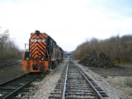
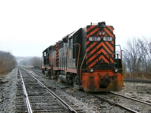
And lastly, I have a couple of photographs of MSW diesels I'd like to submit exclusively to the archives section. How do I do that?
Thanx,
Brian
_________________
High green!! |
|
| Back to top |
|
 |
PWV101
Site Admin
Joined: 04 Apr 2005
Posts: 157
Location: Pittsburgh, PA
|
| Posted: Mon Dec 05, 2005 7: 44 pm Post subject: Answers |
|
|
Thanks for your post. We don't know who owns the old via duct but Jer is looking up the info on the spur. He will post it soon. I sent an email to you about placing your photos on the web site. Any photos we can have access to would be greatly appreciated, giving all a chance to share part of the past with all on this web site.
Thanks,
Jim |
|
| Back to top |
|
|
Web master JZ
Guest
|
| Posted: Mon Dec 05, 2005 8: 53 pm Post subject: P&WV C'ville/MSW |
|
|
Don,t really know who owns the old P&WV C-Bridge, at the present time. Maybe someone on this board can help with information.
MSW Dump spur, looking at the 1962 USG survey map, looks like it may have extended a bit past the Vance 4-lane highway. Was up that way just a week ago. As you drive up the hill from Monessen you can see what appears to be the old ROW just to the right on the crest of the hill. The new road then cuts the line. Piles of slag and old rip-rap ties on the far left , a good clue for an old ROW? Temp. slag-dump spur may have been moved and adjusted several times in it's history.
I have a photo of #24 earily 70's could be on the far-end of the slag dump. Photo information says MSW Pricedale Pa. 12/74. We have photos of 21, 23, 25 , 27 and builders photo of #10. these are in the Mill and Lock area. Circa 1961/62.
This is all we have ...JZ. Mon Valley R.R. Club (New Eagle Pa.) I believe some of the members have a good pile of pics and more information on the MSW R.R. and track plans. |
|
| Back to top |
|
|
ple1556
Joined: 21 Apr 2005
Posts: 42
Location: Monroeville PA
|
| Posted: Wed Jan 11, 2006 8: 49 pm Post subject: Re: P&WV C'ville/MSW |
|
|
[quote="Web master JZ"]
MSW Dump spur, looking at the 1962 USG survey map, looks like it may have extended a bit past the Vance 4-lane highway. Was up that way just a week ago. As you drive up the hill from Monessen you can see what appears to be the old ROW just to the right on the crest of the hill. The new road then cuts the line. Piles of slag and old rip-rap ties on the far left , a good clue for an old ROW? Temp. slag-dump spur may have been moved and adjusted several times in it's history.
I was just wondering because a neighbor of mine when I was younger, Stan Gratta, would tell me stories about how the slag trains would dump in a deep semi-circle pit on Iron city Hill, which is on the east side of the C. Vance highway. And I had always wondered what the construction scenario would have been had the rr still been in existance since it would have to cross over the highway to get to the slag dump. Would Penn Dot have to build an underpass or would WP Steel have to build an overpass or would they have just moved the spur back all together?
_________________
High green!! |
|
| Back to top |
|
|
CuriousGeorge
Joined: 08 Jan 2006
Posts: 50
Location: Monongahela, PA
|
| Posted: Thu Jan 12, 2006 9: 49 am Post subject: Re: P&WV C'ville/MSW |
|
|
| ple1556 wrote: |
I was just wondering because a neighbor of mine when I was younger, Stan Gratta, would tell me stories about how the slag trains would dump in a deep semi-circle pit on Iron city Hill, which is on the east side of the C. Vance highway. And I had always wondered what the construction scenario would have been had the rr still been in existance since it would have to cross over the highway to get to the slag dump. Would Penn Dot have to build an underpass or would WP Steel have to build an overpass or would they have just moved the spur back all together? |
Doesn't the MSW already cross the C. Vance highway? On Rt 201, coming from the shopping district, right before you get to Val's carwash and the 4-lane highway begins, there are two parallel tressels over the road. I have always assumed that these are the PWV & the MSW running parralel before they meet up just east of Rt 201?
Look at Google maps of the area. The first track (bottom) is the PSW, which heads down to the road salt distribution area on the river between Belle Vernon and Monessen. The second track the the PWV. Just nort of that is where the C. Vance Highway begins.
Is this what you are referring to?
Dan |
|
| Back to top |
|
|
ple1556
Joined: 21 Apr 2005
Posts: 42
Location: Monroeville PA
|
| Posted: Thu Jan 12, 2006 11: 19 am Post subject: |
|
|
Well actually, I am referring to a spur that ascends from that interchange. It crosses over the PWV mainline and extends beyond the C. Vance hi-way. It would have crossed over right about where the hiway begins to crest. the ROW of that spur is clearly visible on the west side of the hiway. But not quite sure where it ends on the east as JZ said the ROW may have been moved several times. W-P Steel wasted absolutely no time in taking up these tracks when the mill closed in 1986(?). And as far as I know, if you go to the interchange, you can walk that spur all the way up to where it would have crossed the hiway. The spur is also visible on SOME older USGS topo maps. I can't remember the sight I would have posted it here. I'll look into it. Also, did yunz know there was a wye at the interchange??
_________________
High green!! |
|
| Back to top |
|
|
PWVJer
Joined: 13 Dec 2005
Posts: 946
|
| Posted: Sat Jan 14, 2006 2: 26 pm Post subject: The "Y" at Monessen |
|
|
Here is a photo by Howard Worley looking from the west end "Y" switch.
 |
|
| Back to top |
|
|
M.JCT.
Joined: 01 Jun 2005
Posts: 86
Location: Mifflin Junction
|
| Posted: Sat Jan 14, 2006 5: 37 pm Post subject: Monesson Station 1-11-06 |
|
|
As it is today looking West the station was on the right by the rock and mp marker?
 |
|
| Back to top |
|
|
M.JCT.
Joined: 01 Jun 2005
Posts: 86
Location: Mifflin Junction
|
| Posted: Sat Jan 14, 2006 5: 40 pm Post subject: Monesson Station |
|
|
Looking east
 |
|
| Back to top |
|
|
ple1556
Joined: 21 Apr 2005
Posts: 42
Location: Monroeville PA
|
| Posted: Sat Jan 14, 2006 6: 19 pm Post subject: Question box... |
|
|
WOW!! that picture of the wye is gold!
Yeah, the station sat on the right looking west---some kids burned it down back in 1991, '92, something like that---Boy I always wanted to get the "MONESSEN" sign that hung on the fron of that station!!
Also, I don't see them in that pic of the wye, but right next to the station house there were a few utility sheds where they kept those little maintence cars--I think they were removed in the early 90's but does anybodyknow when they were installed or were they always there and are just out of view??? DOes anybody know when the wye was taken out?? I see 1970 as the copyright date but I would have assumed they were taken out years before that. And what is that bar running along side the left rail? I see that alot at switches....
_________________
High green!! |
|
| Back to top |
|
|
CuriousGeorge
Joined: 08 Jan 2006
Posts: 50
Location: Monongahela, PA
|
| Posted: Sat Jan 14, 2006 8: 45 pm Post subject: |
|
|
| Can you guys point out on a map where this junction in Monessen is? |
|
| Back to top |
|
|
ple1556
Joined: 21 Apr 2005
Posts: 42
Location: Monroeville PA
|
| Posted: Sun Jan 15, 2006 7: 53 am Post subject: |
|
|
Curious,
The Monessen JCT is right next to Val's Carwash, where those 2 rr trestles cross over PA201--that's the Monessen JCT. There's an access road between Val's and the 1 trestle where you can easily drive up and park--It's hard to see because its hidden by overgrowth but it's there.
_________________
High green!! |
|
| Back to top |
|
|
CuriousGeorge
Joined: 08 Jan 2006
Posts: 50
Location: Monongahela, PA
|
| Posted: Sun Jan 15, 2006 12: 14 pm Post subject: |
|
|
| ple1556 wrote: |
Curious,
The Monessen JCT is right next to Val's Carwash, where those 2 rr trestles cross over PA201--that's the Monessen JCT. There's an access road between Val's and the 1 trestle where you can easily drive up and park--It's hard to see because its hidden by overgrowth but it's there. |
Ooooohhhhhh, I know right what you're talking about. I'm familiar with the access road, drive past it quite frequently, but I've never been up there. Didn't think it was anything other than an access road. |
|
| Back to top |
|
|
M.JCT.
Joined: 01 Jun 2005
Posts: 86
Location: Mifflin Junction
|
| Posted: Wed Jan 18, 2006 5: 53 pm Post subject: Monesson Station |
|
|
Here's what it looks like today.Those tracks that took off from the wye did the access the slag dump through this cut ?  |
|
| Back to top |
|
|
PWVJer
Joined: 13 Dec 2005
Posts: 946
|
| Posted: Wed Jan 18, 2006 6: 32 pm Post subject: MSW/P&WV |
|
|
Nope, this was the P&WV Y-track only. old hats tell us "Just room for one 1100 to turn on the stub-end."
The slag spur is about 100 yrds. or so west, (bridge) in your current shot. The MSW crossed over the top of the P&WV main, then went on to the slag-dump location. The MSW ROW is easy to follow in the winter season. |
|
| Back to top |
|
|
M.JCT.
Joined: 01 Jun 2005
Posts: 86
Location: Mifflin Junction
|
| Posted: Wed Jan 18, 2006 8: 02 pm Post subject: Monesson Jct. |
|
|
| Thanks Pwvjer.JR/JZ I remember you posted some photos of this area when you where doing a track walk ,are they on this site somewhere? |
|
| Back to top |
|
|
Guest
|
| Posted: Thu Jan 19, 2006 12: 10 am Post subject: Monessen & CTC |
|
|
Of note to P&WV historians,,,just east of Monessen Station was a crossover that went from the main track to the siding below the MSW connection. Westbounds could head into the crossover where eastbounds had to pull by and back in. There was a dwarf signal protecting the crossover.
In the photos you can see Mile Post 21.
Last year when Bessemer & Lake Erie 909 roamed the P&WV for a few weeks, the 909 made it as far as Monessen. I photographed it sitting in Monessen Siding early one morning showing Mile Post 21 in the foreground. B&LE 909 was a wonderful celebrity for several weeks working the Zug Island coke trains. I managed to photograph the 909 from Monessen to Pittsburgh Junction, Clairton & Mifflin Branches, and many points of interest in between.
Also a point of interest concerning the CTC.
The West End of Monessen had block signals protecting the main track and a dwarf signal coming off the West EMonessen & CYnd of Monessen Siding...where the East End Monessen had only a dwarf signal coming off the siding. The CTC control point for the East End Monessen was about 1/2 miles "east" of the "east switch" at Mile Post 20. There were several locations on the P&WV where the CTC was set up this way...East End Horning...East End Bruceton...East End West Liberty...East End Maple... |
|
| Back to top |
|
|
PWVJer
Joined: 13 Dec 2005
Posts: 946
|
| Posted: Thu Jan 19, 2006 5: 33 am Post subject: MSW/P&WV |
|
|
MJCT. We do have a pile of pics from a track-walk and a few others from the Pre-P&WV era.(Somers Mine). Thanks GPS for the CTC info. We have only some Co. stuff on this from 49'-51'. Looks like lots of changes in the 1960's-70's. We have no pics of these.
JZ/JR. |
|
| Back to top |
|
|
|

