 |
The P&WV Hi-Line
P&WV Technical and Historical Interest Group
|
| View previous topic :: View next topic |
| Author |
Message |
jayrod
Joined: 19 Oct 2007
Posts: 494
Location: Akron, OH
|
 Posted: Tue Aug 16, 2016 7: 22 pm Post subject: Betsy Mine Posted: Tue Aug 16, 2016 7: 22 pm Post subject: Betsy Mine |
 |
|
So as not to hijack the Prototype Consist thread, I have a bunch of questions.... Excuse my ignorance but was the Betsy Mine on a branch up Slab Creek a bit east of Smithfield Station? Boich/Hanna/Pittsburgh/Consol had a lot of acreage in that area and I think the Betsy was opened by Boich. If I'm on the mark, what kind of mine was it, i.e. strip, drift, slope or shaft? The ODNR minerals website has changed and at first pass, I can't seem to find the historical data & maps. When was that branch in operation? Inquiring minds want to know....
_________________
Eric Schlentner
Aka, jayrod |
|
| Back to top |
|
 |
PWVJer
Joined: 13 Dec 2005
Posts: 946
|
| Posted: Wed Aug 17, 2016 8: 32 am Post subject: Betsy Mine info... |
|
|
Ohooo Jez! E-Man , I did'n know there was gonn'a be a TEST!
Well this is what my old brain can remember-recall.
... about Nov. 1926 in this
Smithfield area , Climax, Beluan #1 and #2 mines, Piney Fork and Superior.
All small commercial operators mining coal for the Pittsburgh Coal Co.
These small operations were about a mile or so of each other. The Betsy Mine
appeared in the official P&WV Time table as a Commercial/Industrial
operator Jan. 1938 TT # 25.
Think? the Betsy assumed control over the Climax, Beluan Mines, Superior
and maybe the Wayne #1 & #3.
According WSB records about 1917, there was a bunch of small operations,
as for what kind? Slope, Drift, Shaft ? Operators may have used a verity, did what ever they could do to
mine the rich Pgh.-Seam.
Bet the huge Pittsburgh Coal Co. Empire did not care how the operators mined the product, Company interest was only could the operator
mine-tonnage, pay their bills, and return a nice profit-cut back to Pittsburgh Coal Co.
Slab Creek???
The Betsy Mine was @ MP.99.30, the Smithfield Station listed @ MP.99.8.
...maybe GPS can help me out, add & correct my failing brain-housing -group! |
|
| Back to top |
|
|
jayrod
Joined: 19 Oct 2007
Posts: 494
Location: Akron, OH
|
| Posted: Wed Aug 17, 2016 8: 26 pm Post subject: |
|
|
Boich Coal had a pretty large tract, I think they and the others were bought out by Hanna Coal. Pittsburgh Coal later bought up Hanna stock. Pittsburgh then merged with Consolidate Coal to form Pittsburgh Consolidated. There were a bunch of corporate flips and twists in ownership after that which resulted in Consol Energy but that matters not to P&WV fans. Hence there's always a little confusion when discussing mine owners as it depends on time frame.
Anyway.... The mile posts would put the branch up Slab Creek in about the right spot for either Betsy Mine or a related tipple. The branch took off from the main about 2/3 of a mile east of Smithfield and ran north up Slab Creek about 1.5 miles. That's about all I think I know.
_________________
Eric Schlentner
Aka, jayrod |
|
| Back to top |
|
|
PWVJer
Joined: 13 Dec 2005
Posts: 946
|
| Posted: Thu Aug 18, 2016 9: 01 am Post subject: Betsy Mine |
|
|
...at present, the Hi-Line collection has no images of the Betsy Mine
structures. We do have a few at the crossover just west of the
Smithfield Station. P&WV # 920-whte flags, short train action, looks like heading for the mine,
Brakeman riding the front step, Conductor/Brakeman hanging on the
wood caboose (808-806??) steps. 8/24/41.
and....Two FM's both #56? working hoppers, Hopedale running track? circa: 1955?.
BTW, the official Hi-Line Tech-shop, home-base is complete. Photo-Scanner(s),-Printer(s), high-end PC's, and Nikons/Cannons
are now in their new home/location @ JR's & new-wife's Cecil Pa address.
... after checking for any moving damage & room set-up, one of the first order of business
will be to scan all the large rolling-stock diagrams and drawings,
and get a copy sent to Big-E productions. |
|
| Back to top |
|
|
jayrod
Joined: 19 Oct 2007
Posts: 494
Location: Akron, OH
|
| Posted: Fri Sep 30, 2016 11: 45 am Post subject: |
|
|
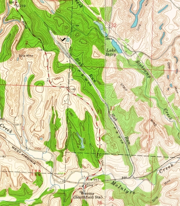
Location of Betsy Mine tipple. To answer my own question, this area was extensively strip mined. This is a combo of the 1960 Smithfield and 1958 Steubenville quads:
_________________
Eric Schlentner
Aka, jayrod |
|
| Back to top |
|
|
PWVJer
Joined: 13 Dec 2005
Posts: 946
|
| Posted: Fri Sep 30, 2016 5: 19 pm Post subject: Betsy Map |
|
|
...HMmm, interesting, nice don't remember ever seeing map(s) from these dates.
... during 1963, 14,373 cars of coal were loaded on the P&WV system,
an increase of 41.1% over 1962.
"Not since 1958 has this much coal been loaded on the P&WV."
____________________________________________________
The Betsy Mine was indeed a factor in keeping the PWV's
fleet of 475 Co. owned, and the 97 leased hoppers very busy.
Along with of course, pool cars from NKP, NYC, B&O and Pennsy. |
|
| Back to top |
|
|
Longview Station
Joined: 16 Apr 2005
Posts: 176
Location: Longview Station
|
| Posted: Thu Oct 06, 2016 7: 47 pm Post subject: |
|
|
Betsy stripped coal up into the 70's if memory serves me correctly. The late Lester Matthews who lived in the company store directly behind Smithfield Station worked there as a truck driver making regular trips to Pittsburgh with mining equipment going to various electrical shops for repair. I'm guessing Smithfield passing siding was no longer needed after Betsy's closing reasoning why its east main track switch was removed and the siding no longer used by the 1980's, however m of w equipment was stored just west of the station as late as 1985 before that station siding trackage was removed.
Also of note, just east of the main track switch into Betsy, just before going into the left handed curve into the cut was the site of a P&WV "cornfield" meet. I have a I.C.C. report here detailing the accident. I |
|
| Back to top |
|
|
PWVJer
Joined: 13 Dec 2005
Posts: 946
|
| Posted: Sun Nov 06, 2016 12: 31 pm Post subject: Hopedale Coal Co. File32-4-6 |
|
|
HMmmm... today, while looking/searching for additional Betsy Mine info/Line Drawings, etc.
P&WV official Records/Archives, un-covered (again) an extensive folder filled with info on Hopedale Coal Co.
( Harmon Creek Coal Co. - Howard Mine ) from February 18, 1918 to
June 1, 1923.
Several years back, think ?? I recall Line Diagrams - Blue-Prints-Maps.
Hopedale Water-Tower, Pump-House, Station, and some related Coal Co.
out-Buildings near the ROW. Circa: late 1930's?
...as yet, have not un-covered any additional Betsy Mine stuff !
Archive search(s) will continue next week. |
|
| Back to top |
|
|
Longview Station
Joined: 16 Apr 2005
Posts: 176
Location: Longview Station
|
| Posted: Sun Nov 20, 2016 6: 31 am Post subject: |
|
|
This was posted on another group recently by Tom Barnett;
Back in 1966, I worked Piney Fork as agent/operator for NYC and would talk via city phone 733-7182 to the N&W agent at that depot in Smithfield. His name was Bob Perrin and he lived over at Avella, Pa and was an ex P&WV man. The P&WV regularly interchanged coal, which loaded at the PWV served Boich Mining Co's Betsy Mine which was located about 1/2 mile of the Smithfield depot and was destined to General Portland Cement at North Paulding, Oh routed PWV Hopedale NYC. Betsy Mine also loaded for CEI Willoughby, Oh same routing. I've visited that depot when it was still manned by a real live station agent quite a few times.
There is a photo to go with the information taken from a eastbound passing the front of Smithfield Station but I don't know how to attach it? |
|
| Back to top |
|
|
PWVJer
Joined: 13 Dec 2005
Posts: 946
|
| Posted: Sun Nov 20, 2016 11: 17 am Post subject: Hopedale & Betsy Archives |
|
|
We have started to put another batch of Archive info,
original (maps/drawings/blue-prints-diagrams) related to the Hopedale & Betsy
Coal operations in Ohio.
Some of these will be sent over to Dave D.(WM-Historian) for
TLC restoration/repair work.
This must be done to make it easy to scan & record these documents.
Un-covered some interesting original documents about the
Harmon Creek Coal Co. operations. Below is a small sample letters/reports.
" ... Oct. 25, 1921 as you are aware this mine (Howard Mine) is a
stripping operation and uses its own engines to handle the empties & loads
after the empties are placed on their siding by our P&WV engines. "
... " there is plenty of shoulder, but the track is not safe for one of our 900 class engines to operate..."
..." This same conditions exists at practically all of the stripping operations
along our P&WV line...... "
Bits of info are suggesting the power was leased or bought S.H. from
the W&LE. 0-4-0 older tank ???? and Brewester built 0-6-0's ????
... at some point the Hi-Line may be able to assemble complete operation stories, matching the maps & drawings to the written letters and
reports for both the Steam circa: 1920's-30's. to Diesel circa: 1950's-early 60's. |
|
| Back to top |
|
|
jayrod
Joined: 19 Oct 2007
Posts: 494
Location: Akron, OH
|
| Posted: Sun Nov 20, 2016 9: 08 pm Post subject: |
|
|
When I'm not so crazy busy, I'll go through the Ohio GIS mine maps and compile a list of sidings/mines on the PWV. Underground mines were required to periodically file maps with the state since the mid(?) 1800s. Strip mines are/were not required to file maps so those may be harder to pinpoint if they only had a one-track siding next to the main. Picking and clicking through all that data is a mind-numbing chore but with a big tourine of coffee and a couple dozen donuts, I should be able to get through it. I can mark these on Blane's Google map, also.
_________________
Eric Schlentner
Aka, jayrod |
|
| Back to top |
|
|
|
|
You cannot post new topics in this forum
You cannot reply to topics in this forum
You cannot edit your posts in this forum
You cannot delete your posts in this forum
You cannot vote in polls in this forum
|
Powered by phpBB 2.0.20 © 2001, 2002 phpBB Group
|

